


PRECINCT BDM 48, Mahoning County, Ohio
About
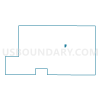
Outline

Summary
| Unique Area Identifier | 649519 |
| Name | PRECINCT BDM 48 |
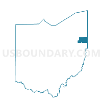
| County | Mahoning County |
| State | Ohio |
| Area (square miles) | 0.32 |
| Land Area (square miles) | 0.32 |
| Water Area (square miles) | 0.00 |
| % of Land Area | 99.49 |
| % of Water Area | 0.51 |
| Latitude of the Internal Point | 41.03808900 |
| Longtitude of the Internal Point | -80.70755850 |
Maps

Graphs
Select a template below for downloading or customizing gragh for PRECINCT BDM 48, Mahoning County, Ohio


Neighbors
Neighoring Voting District (by Name) Neighboring Voting District on the Map
- PRECINCT BDM 13, Mahoning County, OH
- PRECINCT BDM 49, Mahoning County, OH
- PRECINCT BDM 8, Mahoning County, OH
- PRECINCT CNT 5, Mahoning County, OH
- PRECINCT CNT 7, Mahoning County, OH